Wow! This news about the Stonehenge complex is fascinating:
Newly Uncovered “Super Henge” Dwarfed Stonehenge
Every summer solstice, tens of thousands of people throng to Stonehenge, creating a festival-like atmosphere at the 4,400-year-old stone monument. For the 2015 solstice, they will have a bit more room to spread out. A just-completed four-year project to map the vicinity of Stonehenge reveals a sprawling complex that includes 17 newly discovered monuments and signs of 1.5 kilometer-round “super henge”.
The digital map — made from high-resolution radar and magnetic and laser scans that accumulated several terabytes of data — shatters the picture of Stonehenge as a desolate and exclusive site that was visited by few, says Vincent Gaffney, an archaeologist at the University of Birmingham, UK, who co-led the effort.
Take the cursus, a 3-kilometer-long, 100-meter-wide ditch north of Stonehenge that was thought to act as barrier. The team’s mapping uncovered gaps in the cursus leading to Stonehenge, as well as several large pits, one of which would have been perfectly aligned with the setting solstice Sun. New magnetic and radar surveys of the Durrington Walls (which had been excavated before) uncovered more than 60 now-buried holes in which stones would have sat, and a few stones still buried.
“They look as they may have been pushed over. That’s a big prehistoric monument which we never knew anything about,” says Gaffney, who calls the structure a ‘super henge.’ His team will discuss the work at the British Science Festival this week, and they plan to present it to the institutions that manage the site. “I’m sure it will guide future excavations,” Gaffney says.
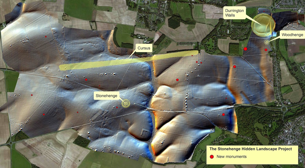
Superhenge monuments distribution map (Nature.com)
We feature the Cursus at Stonehenge in our 2015 Astrotheology Calendar, which explores ruins and myths about the solstices and equinoxes. The Cursus monument is aligned to the equinoxes, while a couple of pits near it align with the solstices.
We would expect many more such archaeoastronomical alignments in this massive “Superhenge” complex. We look forward to more news on that front, which undoubtedly will take many years to map out. Such analysis is already under way, as one excavation report states:
Work also revealed novel types of monument including massive prehistoric pits, some of which appear to form astronomic alignments, plus new information on hundreds of burial mounds, Bronze Age, Iron Age and Roman settlements and fields at a level of detail never previously seen. Taken together, these results – which will be featured in a major new BBC Two series titled Operation Stonehenge: What Lies Beneath – show that new technology is reshaping how archaeologists understand the landscape of Stonehenge and its development over a period of more than 11,000 years.
Further Reading
Digital mapping uncovers ‘super henge’ that dwarfs Stonehenge
The Stonehenge Hidden Landscape Project